Loading...

Approved Vendor Products:
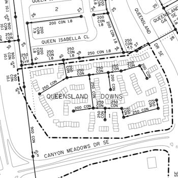
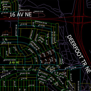
1:4000 Base Map - Sanitary
FreeThis set of utility files shows information for Sanitary Sewer System infrastructure within the city of Calgary. These files are updated annually and are a digital representation of the pages from the annual publication of the “1:4000 Section Map books” that are provided in hardcopy. The property linework is not included in these files but is available through the LSF and OPF product. Each PDF file depicts one legal section of the city of Calgary, overlaid with the Sanitary Sewer System infrastructure information for that section. The applicable legends, conversion tables, and any other relevant information required to understand these maps are available for download at no cost.
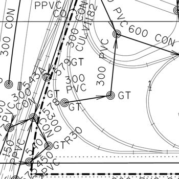
1:4000 Base Map - Storm
FreeThis set of utility files shows information for Storm Sewer System infrastructure within the city of Calgary. These files are updated annually and are a digital representation of the pages from the annual publication of the “1:4000 Section Map books” that are provided in hardcopy. The property linework is not included in these files but is available through the LSF and OPF product. Each PDF file depicts one legal section of the city of Calgary, overlaid with the Storm Sewer System infrastructure information for that section. The applicable legends, conversion tables, and any other relevant information required to understand these maps are available for download at no cost.
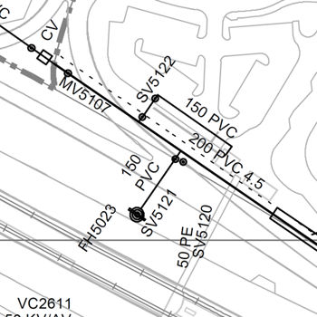
1:4000 Base Map – Water
FreeThis set of utility files shows information for Water System infrastructure within the city of Calgary. These files are updated annually, and are a digital representation of the pages from the annual publication of the “1:4000 Section Map books” that are provided in hardcopy. The property linework is not included in these files but is available through the LSF and OPF product. Each PDF file depicts one legal section of the City of Calgary, overlaid with the Water infrastructure information for that section. The applicable legends, conversion tables, and any other relevant information required to understand these maps are available for download at no cost.
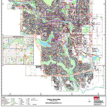
Calgary Street Map - PDF
FreeThis city-wide map of Calgary shows major and collector roads, major road annotations, LRT tracks, stations, hydrography, parks, golf courses and transportation utility corridors. This is a map in .PDF format and is 42”x58” in size. This .PDF can be later used for wall map printing.
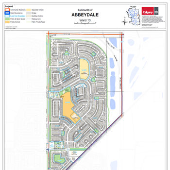
Community Address Maps by Name – PDF
FreeThe PDF map includes addresses, land use districts, streets and street names, buildings, parks and schools.
Digital Aerial Survey (DAS) by Section - AutoCAD
FreeDerived from 1:5000 color aerial photos, the DAS product provides surface features and topography to within an accuracy of 15cm horizontally and vertically.
Digital Aerial Survey (DAS) by Section - Microstation
FreeDerived from 1:5000 color aerial photos, the DAS product provides surface features and topography to within an accuracy of 15cm horizontally and vertically.
Digital Aerial Survey (DAS) by Section - Shapefile
FreeDerived from 1:5000 color aerial photos, the DAS product provides surface features and topography to within an accuracy of 15cm horizontally and vertically.
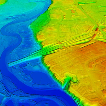
Digital Elevation Model (DEM) by Section - ASCII 1M
FreeThis highly accurate elevation dataset of ground surface topography is derived from aerial Light Detection and Ranging (LiDAR). This 1m resolution version of the bare-Earth LiDAR DEM can be used for a wide range of applications such as 3D spatial analysis (slope calculations, profile creation, volumetric computations), engineering applications (land developments, road design, flood modelling) and 3D terrain visualizations, just to name a few. DEM of 2m and 20cm resolution are also available. It is available for immediate download with digital licensing. DEM maps are sold per ATS section. ATS Section naming structure: Section – Township – Range – Meridian (SSTTRRM) Data coverage is within the corporate city limits plus about 100 meters beyond.
Digital Elevation Model (DEM) by Section - ASCII 20CM
FreeThis highly accurate elevation dataset of ground surface topography is derived from aerial Light Detection and Ranging (LiDAR). This full 20cm resolution, bare-Earth LiDAR DEM can be used for a wide range of applications such as 3D spatial analysis (slope calculations, profile creation, volumetric computations), engineering applications (land developments, road design, flood modelling) and 3D terrain visualizations, just to name a few. DEM of 2m and 1m resolution are also available. It is available for immediate download with digital licensing. DEM maps are sold per ATS section. ATS Section naming structure: Section – Township – Range – Meridian (SSTTRRM) Data coverage is within the corporate city limits plus about 100 meters beyond.
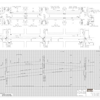
Electronic Block Profile - TIFF
FreeA Block Profile is a detailed engineering drawing of a record containing features within a public right-of-way. The Block Profile Plan is divided into three parts: two Plan Views and one Profile, with the exceptions of major roads and large right-of-ways. 1. The Top Plan View shows surface features, legal descriptions, and bordering property data. 2. The Utility Plan View shows utility locations within the public right-of-way and related data. 3. The Profile shows public right-of-way and utility grades and related data.
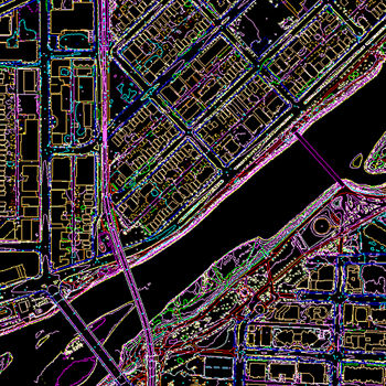
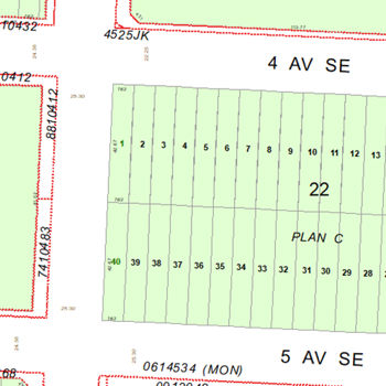
Legal Survey Fabric (LSF) by Section - AutoCAD
FreeThe Legal Survey Fabric Product outlines tentative, preliminary, and registered plans within the city. Its contents include: Registered Plan Number & Shape, Block Numbers & Linework, Lot Numbers & Linework, Legal Dimensions & Street Names, and Easements/URW.
Legal Survey Fabric (LSF) by Section - Microstation
FreeThe Legal Survey Fabric Product outlines tentative, preliminary, and registered plans within the city. Its contents include: Registered Plan Number & Shape, Block Numbers & Linework, Lot Numbers & Linework, Legal Dimensions & Street Names, and Easements/URW.
Legal Survey Fabric (LSF) by Section - Shapefile
FreeThe Legal Survey Fabric Product outlines tentative, preliminary, and registered plans within the city. Its contents include: Registered Plan Number & Shape, Block Numbers & Linework, Lot Numbers & Linework, Legal Dimensions & Street Names, and Easements/URW.
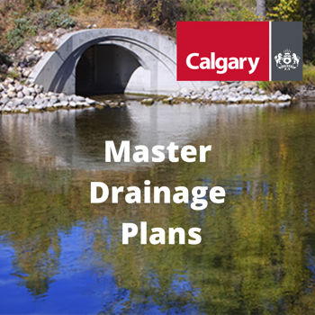
Master Drainage Plans
FreeMaster Drainage Plans (MDPs) are conceptual-level stormwater drainage plans, in support of Area Structure Plans, and prepared for large drainage areas serviced by (usually) a single outfall to a receiving water body such as the Bow River. MDPs are developed through the evaluation of alternatives that provide an acceptable level of service while meeting the objectives of over-arching Watershed Plans or Water Management Plans and satisfying any constraints imposed by topography, land uses, and land ownership. MDPs typically identify and locate major stormwater ponds, other BMPs, trunk sizes and servicing routes, overland drainage routes, water quality and wetland and stream habitat preservation requirements, and land requirements.
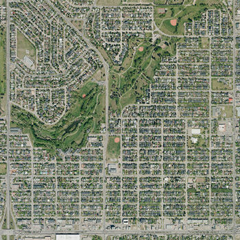
Orthophotos 2018
FreeAn orthophoto is an aerial photograph, geo-referenced and geometrically corrected to have a uniform scale, that can be situated accurately on a digital map. They are available for immediate download with digital licensing. The orthophoto may be used for referencing but may not be distributed or republished without permission. These orthophotos cover the entire City of Calgary with at least a 2 km buffer beyond the city's boundary. As a result, some sections beyond the city limits may be incomplete.
Orthophotos 2019
FreeAn orthophoto is an aerial photograph, geo-referenced and geometrically corrected to have a uniform scale, that can be situated accurately on a digital map. They are available for immediate download with digital licensing. The orthophoto may be used for referencing but may not be distributed or republished without permission. These orthophotos cover the entire City of Calgary with at least a 2 km buffer beyond the city's boundary. As a result, some sections beyond the city limits may be incomplete.
Orthophotos 2020
FreeAn orthophoto is an aerial photograph, geo-referenced and geometrically corrected to have a uniform scale, that can be situated accurately on a digital map. They are available for immediate download with digital licensing. The orthophoto may be used for referencing, but may not be distributed or republished without permission. These orthophotos cover the entire City of Calgary with at least a 2 km buffer beyond the city's boundary. As a result, some sections beyond the city limits may be incomplete.
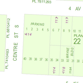
Ownership Parcel Fabric (OPF) by Section - AutoCAD
FreeThe Ownership Parcel Fabric Files are like LSF files but with the additional depiction of the private ownership of parcels and graphically outlined boundaries indicated with municipal addresses. Utility right of ways, legal dimensions and lot lines are not included from the LSF files.
Ownership Parcel Fabric (OPF) by Section - Microstation
FreeThe Ownership Parcel Fabric Files are like LSF files but with the additional depiction of the private ownership of parcels and graphically outlined boundaries indicated with municipal addresses. Utility right of ways, legal dimensions and lot lines are not included from the LSF files.
Ownership Parcel Fabric (OPF) by Section - Shapefile
FreeThe Ownership Parcel Fabric Files are like LSF files but with the additional depiction of the private ownership of parcels and graphically outlined boundaries indicated with municipal addresses. Utility right of ways, legal dimensions and lot lines are not included from the LSF files.
Road Network (RoadNet) Citywide – AutoCAD
FreeThe Road Network (RoadNet) product is a single line graphical representation of the City of Calgary road network consisting of planned, unbuilt and built drivable surfaces. The product is currently used by 44 major corporate and external client groups with several hundred thousand subsidiary users. This graphical form of the data is used as a backdrop for a variety of maps including Transit Bus Route Maps, Parks Bike Pathway Maps and AMA Route Maps.
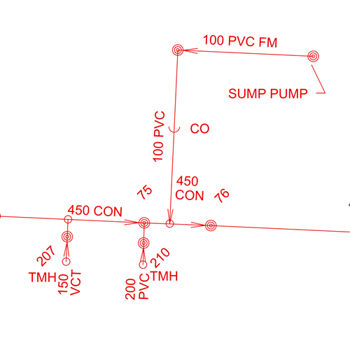
Sanitary Utilities by Section - AutoCAD
FreeThis set of utility files show information for Sanitary Sewer System infrastructure within the city of Calgary. The property linework shown is not included in these files, but is available through the LSF & OPF product.
Sanitary Utilities by Section - Microstation
FreeThis set of utility files shows information for Sanitary Sewer System infrastructure within the city of Calgary. The property linework shown is not included in these files but is available through the LSF & OPF product.
Sanitary Utilities by Section - Shapefile
FreeThis set of utility files shows information for Sanitary Sewer System infrastructure within the city of Calgary. The property linework shown is not included in these file, but is available through the LSF & OPF product.